Author Archives: Steven


About Steven

All about Steven

EPIC CYCLE TOURING: NORTH SULAWESI, INDONESIA

After our first two-wheeled adventure in South Africa last Fall, I’ve been banging on about the sheer awesomeness of going on an epic long-distance cycle tour.   Sal needed a break from too many airports and global traveling especially after for months of Middle East and African travel last year alone.  She’s been to Indonesia and many countries in that area, I haven’t.  I hoped to find some local biking tours as I was traveling so I took a chance and went ahead to do some serious training here at home such as daily long bike rides plus two metric century bike rides (each over 63 miles).

In Jakarta, a local government tourism service office was able to locate an Australian company, Cycling Indonesia.  There, by a stroke of luck, the next cycling tour was to begin in 5 days in Manado, North Sulawesi, over 1350 miles away. This 13-day biking tour has a distance of about 400 miles with a whopping elevation gain of over 26,000 feet.

FullSizeRender

I was to meet Colin, the 72-year-old owner/bike guide, at the Manado Airport, and other two bikers, Gil, a 58-year-old Australian lady and Rick, a 69-year old American and Ucok, a local sag wagon driver/bike mechanic.  Best of all, a decent bike was waiting for me!

Gil couldnt resist kissing this handsome four-legged feller!

IMG_8327

IMG_8323

Along the route starting from Manado ending at Gorontalo, we stayed in nine types of accommodations, from International hotel, and quality village homestay to beachside guesthouse and cottage by the beach.  We slept under a looming, still active Gunung Lokon volcano (erupted last May 2015), as well as shoreside on Tondano Lake, by the warm Celebes Sea up north toward the Philippines to soaks in hot thermal water. We ate a variety of meals from family homes to amazing local restaurants along the way.

IMG_8330

Speaking of food, there are many plantations including coconuts, pineapples, clove, chocolate, chilies, and coffee.  Best of all we enjoyed many types of fresh fruit, our favorites were the mangosteen, round, apple-sized, deep purple fruit easily cracked opened by pressing between both palms and the snakeskin fruit,  with a sweet and slightly starchy consistency, a cross flavor between pineapple and sweet apples. My favorite was rambutan/buluan, especially the reddish long-haired types with very juicy flesh. Yum!

At times with high heat and extreme humidity, the climbs were very uncomfortable, accomplished with team support and with borderline insane amounts of humor.  As an example, Gil (below) had to try that 15-plus pound bag out!

IMG_8329

The best part of this amazing trip is the local people, young and old, greeting us with warmth and enthusiastic smiles.  Riding through large minority religious groups, inter-religious harmony is the norm, with many mosques and churches everywhere.  While riding, I enjoyed reaching out to give high-fives to least a couple of hundred children and always exchanging loud greetings, “Selamat Pagi!” (Good Morning) and “Selamat Siang!” (Good Afternoon).  Already, I am missing their infectious giggle fits!

IMG_8324

A STEP BACK IN TIME: HARPER’S FERRY & GETTYSBURG

How often have you read stories regarding the history of the United States, and wondered what it might have been like to actually be there?  We build a mental picture in our minds filtered through our imaginations from our reading, or we see grainy pictures of those who lived in those historic times, but we can never really grasp the true magnitude of what it might have been like. My perception of history changed completely the day I stepped out of our RV at both the Harper’s Ferry National Historical Park and the Gettysburg National Military Park, the crown jewels in the National Park Services.  It was a rather intense to experience American losses and suffering at the hands of a civil war by walking the hallowed grounds!

At the Harper’s Ferry, a little neck of land tucked between the confluence of the Potomac and Shenandoah Rivers, where three states (MD, VA and WV) meet, our interest there was the 1859 raid on Harper’s Ferry by the abolitionist John Brown.

confluence

On the night of October 16, 1859, Brown, 59 years old, staged his most daring  raid, an assault on the federal armory in Harpers Ferry, Virginia, which housed an arsenal of more than 100,000 rifles and muskets.  Calling his raiding force, the “Provisional Army,” Brown’s group of 22 men included three of Brown’s sons, a fugitive slave and four free blacks.  Brown’s goal was to seize the arsenal, distribute the guns and muskets, mobilize anti-slavery forces, incite slave insurrections and organize raids against slaveholders across the South. Brown and his men initially took control of the armory, but within 36 hours, U.S. Marines under the leadership of future Confederate generals, Colonel Robert E. Lee and J.E.B. Stuart, stormed the facility, killed several of Brown’s band and captured Brown and the remaining raiders. Brown was taken to nearby Charles Town, then in Virginia, where he was charged on three counts: treason, murder and conspiracy to lead a slave rebellion.  After a seven-day trial and forty-five minutes of deliberation, the jury found him guilty on all counts and sentenced him to death.  Ironically, the actor John Wilkes Booth witnessed his execution and would later assassinate the President Lincoln about five and a half years later.

brown

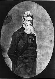
At that time, Brown appeared as a Biblical Samson-like figure who sought to tear down the institution of slavery through an incredibly bold, self-conscious of self-sacrifice.  His death may have indeed brought searing moral indictment of the slave system, ultimately leaving the south with little credible response but to secede from the union and engage in Civil War. This event is now considered one of the catalysts of the U.S. Civil War (1861-1865). Four years later, the battles at Gettysburg and Vicksburg, arguably changed the course of the war as notable Union victories.

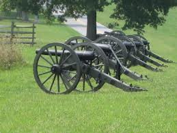
After winding our way 58-mile northwest drive in 25mph arctic wind, to the historic Gettysburg battleground in Pennsylvania, we took advantage of  the 24-mile auto tour route within the historic Gettysburg National Military Park in Pennsylvania. The muddy icy grounds we experienced were likely extremely wearing for both Union and Confederate soldiers. Mile after mile of cannons, statues, monuments, and plaques along the ridges held by the Northern Virginia Confederate Army provided a palpable sense of the masses of American resources in men and arms committed to the war. Every unit that fought here is memorialized, with numbers of casualties listed: the small numbers are oddly more powerful than the large, a unit of some dozens of men, half or more of whom fell. Units were organized regionally then, so when names are listed alphabetically, it’s brother after brother, like some kind of family roster, unit by unit along the Union and Confederate lines. Numerous cannons are placed in the battle’s many artillery positions, and statues of significant participants are strategically placed at the sites of their heroism.

cannons

Here’s a quick summary of the most famous 1863 Civil War battle: it was the “high water mark” of the Confederacy; the turning point of the war; and 51,000 Americans were killed in this three-day battle.  To put that horrific number into context, a bit more than 58,000 Americans were killed in the entire 10-year Vietnam war.

In 1863, at the beginning of the most famous Civil War battle, Gen. Robert E. Lee concentrated his full strength against Maj. Gen. George G. Meade’s Army of the Potomac at the crossroads county seat of Gettysburg.

On July 1, Confederate forces converged on the town from west and north, driving Union defenders back through the streets to Cemetery Hill. During the night, reinforcements arrived for both sides.

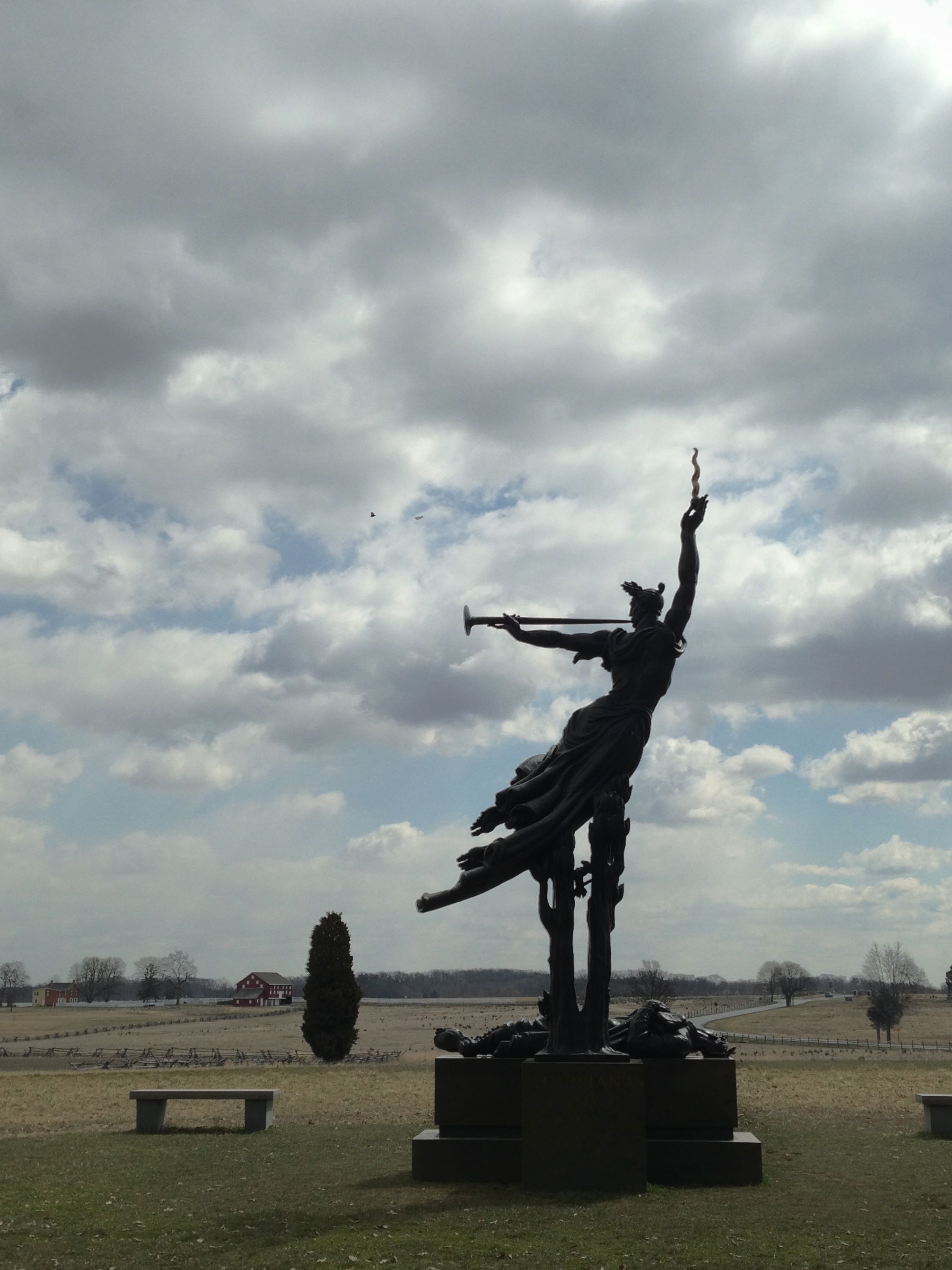
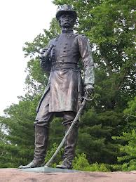
On July 2, Lee attempted to envelop the Federals, first striking the Union left flank at the Peach Orchard, Wheatfield, Devil’s Den, and the Round Tops with Longstreet’s and Hill’s divisions, and then attacking the Union right at Culp’s Hill and East Cemetery Hill with Ewell’s divisions. By evening, the Federals retained Little Round Top and had repulsed most of Ewell’s men. Little Round Top is particularly fascinating. This hill, on the Union left flank, was possibly the most important position on the battlefield, and standing atop it, I can see why: it commands a view of the entire valley, and much of the battlefield. A statue stands atop a large rock, of Brigadier General Gouverneur K. Warren, the Union chief engineer, looking out across the valley. During the battle, General Warren discovered that this hill was undefended, and saw Confederate forces ready to attack the Union flank; he rushed to find soldiers to hold the hill.   I can see what General Warren saw: the tree line where the Rebels were within sniper range. Confederate sharpshooters using scoped rifles could shoot a man on this hill from a concealed position. Suddenly those big rocks look very important.

warren

Standing at the bottom of Little Round Top, I can see what the Rebels were up against. It’s not a large hill: it rises about 150 feet from the valley floor. But the rocky terrain makes it formidable. I wouldn’t want to climb this slope with heavy armaments, even without anyone shooting at me. This was an important hill indeed.

During the following morning of July 3, the Confederate infantry were driven from their last toe-hold on Culp’s Hill. In the afternoon, after a preliminary artillery bombardment, Lee attacked the Union center on Cemetery Ridge. The Pickett-Pettigrew assault (more popularly, Pickett’s Charge) momentarily pierced the Union line but was driven back with severe casualties. Stuart’s cavalry attempted to gain the Union rear but was repulsed.

On July 4, Lee began withdrawing his army toward Williamsport on the Potomac River. His train of wounded stretched more than fourteen miles.

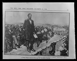
But, in a larger sense, we cannot dedicate, we cannot consecrate, we cannot hallow this ground. The brave men, living and dead, who struggled here, have consecrated it far above our poor power to add or detract.  Well said, Mr. President Lincoln.

getty_linconl

BEAUFORT AND HUNTING ISLAND: SOUTH CAROLINA

Along the “Lowcountry” a stretch of sea islands and coastline is deeply effected by the sweeping tides. Our RV is bouncing along, winding up the coastal waterways, following the lazy yet pristine water along miles of undisturbed marshes and acres of natural woodlands. This area is teeming with wildlife, and larger trees, commonly Live Oak and Bald Cypress with their Spanish Moss, long graybeards dangling low.  There, a lovely picturesque town of Beaufort (it’s pronounced BE-YOU-FERT) sits alongside the Beaufort River.  Charted in 1711, it is the second-oldest city in South Carolina, behind Charleston.  Also, it is one of the few cities with its entire downtown designated by the National Trust for Historic Preservation as a historic district.  No wonder several major motion pictures, including Forrest Gump, The Prince of Tides, The Big Chill, Forces of Nature, and the Great Santini, just to name a few, were all made here.

image

We enjoyed walking all over the oak and moss lined streets and especially the charming Henry C. Chambers Waterfront Park.  From one of the numerous large bench-sized swings there, overlooking the Beaufort River, we went swinging wildly like children all over again ~ whee!

From Beaufort, about 20 miles southeast along the Sea Island Parkway, we discovered an amazing gem, the Hunting Island State Park and its 1859 Lighthouse. We scored a beachfront campsite about 30 feet from the breaking waves and soothing ocean roars for two wonderful nights.  This was fortunate, as it is the most popular state park in South Carolina, even during the the lowest attendance month of the year.  On the first night under a brilliant half-moon with its piercing Jupiter, I went out on the beach and noticed that the lighthouse in the near distance was actually rotating its light toward the ocean ~ what a treat!  Before sunrise, I took a quick walk down the beach toward the lighthouse and noticed a veritable graveyard of trees lying unburied on the wide expansive beach.  This island suffers major beach erosion yearly, ranging from 7 to 15 feet of land lost yearly to the sea. Since 2000, 50 to 250 feet of land lost means houses, roads, campsites and forests have been washed away. A 16-year annual camper at this park, pointed out that her favorite site likely would be the next one lost to the ocean, along with the road providing access to our site….thus the large tree graveyard there. They used to bring in sand and rock to provide erosion relief, but now allow nature to have her way, as we know she will in the end.

20110226_062730_Beach_Sunrise_edit.jpg


St. George Island ~ it’s the Forgotten Coast…!

Thanks to cousin Katy’s recommendation – we were lucky enough to spend a three-day break lazing on a small, sleepy barrier island in Florida – St. George Island to be exact.  It’s in the panhandle, between Panama City and Tallahassee.  Whether foggy or sunny, the wind provided enough chop that kayaking was not a fun option.  Days usually included a nice walk or long bike ride in the morning, followed by the beach and reading for several hours, and then some good, local seafood in the evening.

The lighthouse on the island

St. George Island is 28 miles long and 2 miles wide; it is located 4 miles off the mainland.  With miles of undeveloped beaches, the local State Park and Campground is a rare find.  Though on one end lies a very exclusive, gated community with its own airstrip, the rest of the island is very laid back; down-home beach bum might be a better description.  There are many areas left undeveloped, and no building can be taller than 3 stories.  There are only about 5 restaurants/bars on the island, and it is a VERY dog friendly area.  Dogs are allowed on the beach and in most all of the restaurants. It was not uncommon for people to introduce their dogs first so we had to figure out if “Lucy” was an owner or a dog. Some of our favorite dog hang outs:

Eddie Teach’s – a great open air, dive bar, with a working wifi.  Open for lunch, dinner, and late-night bar with live caribbean music. We arrived in time for their weekly trivia game, and could help our team, “Lucy’s (the dog) Bunch” with the rock n’ roll trivia. They have a “happy hour” Monday – Friday at 3:30 – 4:30 with half price raw or steamed oysters.  Plus, they have a really good list of draft and bottled beers.  The oysters there were fresh and had a more flavorful, muskier taste than the Tomales Bay type we are accustomed to at home.

The town on the mainland before you head over the bridge to St. George is called Apalachicola and it is very cute  – a smaller coastal fishing town with more of the “Old Florida” feel.  House boats, seafood restaurants, some good history spots. We enjoyed a popular local hangout, Cafe Con Leche featuring local artists and blasting show tunes.  There, you can watch the local fishing fleet unload the catch of the day while you eat a slice of fresh vegan fig/almond saffron cake with a fig buttercream icing….are you drooling yet? No? Then accompany it with their house coffee, the “Deep Blues Blend” by the coffee company, Muddy Waters Coffee, sporting a logo of the great man playing.  As promised, it will “Wake Up Your Soul!”

Fishing boats in Apalachicola at the mouth of the Apalachicola River produce a whopping 90 % of Florida’s oysters and 10% of the nationwide supply.  Over 2.6 million pounds of oyster meat is harvested annually.  A perfect day to end our visit to the Forgotten Coast!

THE THRILL IS HERE!: Riley B.B. King and Mississippi Delta Blues

Today, the one and the only king of the blues, B.B. King is 87 years old still traveling 360 days a year, performing 200 concerts a year with his ebony queen guitar, Lucille.  Yes, the THRILL IS HERE…!

IMG_1292

In King’s childhood home, there was little music but he got plenty of inspiration at church.  He grew up singing in a gospel choir and the pastor there, his first idol, played the electric guitar, preached and sang.  In turn, King bought a $15 acoustic guitar when he was 12.  Eventually, playing gospel on the streets, it was the lousy tippers who led King to performing the Blues for bigger tips.

In 1948, King began working at a Memphis radio station as a singer and disc jockey called “The Beale Street Blues Boy” – soon shorten to “B.B.”  In 1948, he began recording and touring as “B.B. King”.

Yes, it was a woman who inspired King to name all his guitars “Lucille.”  It happened in 1949 when he was playing at a place in Twist, Ark.  It was very cold and they had a big garbage pail filled with lit kerosene for heat.  Two guys started fighting, and one knocked the other into that barrel, and it spilled on the floor.  The place was burning rapidly, everyone ran outside, and King left his guitar inside.  Even though the building was falling in, King went back for his guitar.  In turn, he almost lost his life.  Two people died that night, and the next day, King learned the men that caused it all had been fighting over a woman.  King never did meet her, but they said her name was Lucille.  He named his guitar Lucille as a reminder to never do something so foolish again.  And he hasn’t. He just works…non-stop. He has been honored by every musician that has played with him for his kindness and his professionalism.

King has won 15 Grammy Awards and has created dozens of hits, including the “The Thrill is Gone” and “Lucille.”  He was inducted into The Blues Hall of Fame in 1980 and The Rock and Roll Hall of Fame in 1987.

The Mississippi Delta where King was born is the distinctive northwest section of Mississippi and generally considered to be the birthplace of the Blues, with the new musical form emerging around the turn of the 19th century. But the story of the Blues dates back before the Civil War and to the West coast of Africa where countless men, women and children were captured by slave traders and shipped across the Atlantic for forced labor on Southern plantations when it was one of the richest cotton-growing areas in the nation.

Slaves from many African countries carried the songs and music of their respective homelands to America. There, amidst the hard work, fear and oppression, the slaves found a temporary escape in music and expressed both hope and despair in their songs. The musical traditions of numerous African cultures blended as the slaves worked side by side in the steamy fields of the south. Field hollers and work songs were a means of expression and communication — which were often not otherwise allowed by the plantation overseers. With few instruments and little or no money, the slaves used their own voices and clapped percussion as musical tools. Their original methods of creating music became significant elements in the creation of the raw Delta Blues style.

As slaves — and then freed slaves — became more integrated into American culture, the church became a regular part of their Sundays. While the white churchgoers sang formal hymns, the black Southerners brought their passionate vocals, clapping, stomping, and call-and-response methods of singing into their own churches. By the 1870s the Mississippi Delta was fertile ground for the roots of the blues. With its history of slavery, racial oppression, the Ku Klux Klan, and Jim Crow laws, plus baking heat, rampant illiteracy and poverty, the Delta was a cruel place for many African Americans well into the middle of the 20th century. The Blues documented the experience of southern blacks better than any other form of cultural expression.

The Delta area has produced the largest number of influential and important blues artists and, though never a major center of the music business, it is still the emotional heart of the Blues for musicians, fans, travelers, and historians.

This eventually led to acceptance of the Blues as a viable musical form and launched it into the mainstream and beyond black folk culture, forever changing the face of American music. It moved from the nomenclature, “Race Music” to “Crossover Music” for white audiences as well.

Today in Mississippi Delta, where King was born and raised, it is filled with Blues museums, but this one, The B.B. King Museum and Delta Interpretive Center in Indianola, ranks at the top. A magnificent tribute not only to Mr. King, but also to Delta and Black History.  The cotton gin that King worked in the 1940s as a tractor driver, has been restored along with this well-designed ultra modern museum including King’s beloved guitar, Lucille, and his home recording studio. The permanent exhibition is moving and at times overwhelming at the depth of negative history, but it tells the stories that must be told. We bought tickets at the Museum for some Blues performances at the still existing Club Ebony in Indianola where he comes back to play yearly at the large Blues Festival. The pre-Xmas crowd was friendly, cuttin’ a rug, and made us feel welcome as the only non-locals in a small, black southern community.

IMG_0610

Make sure you put this on your list of places to visit — from the cotton fields, street corners and juke joints of the Mississippi Delta came a new kind of music – the Blues. Considered by many to be the only truly indigenous American music, this form that has influenced musicians worldwide is deeply rooted in Delta soil. And so is the man who helped spread the Blues as its foremost ambassador…

Riley B.B. King’s “The Thrill is here…!”

Ah, the Great Smoky Mountains…

Right after earning my brand spanking new driver license at the age of 15 and a half, I celebrated by driving for a long five hours through the nicest country – all the way from my Kentucky hometown, Louisville, to the Great Smoky Mountains right on the borders of Tennessee and North Carolina.  Right up there at the highest point, Clingsman Dome (6,643 feet), my friend and I backpacked and camped out for several days.  It is the highest mountain of the entire 2,174-mile Appalachian Trail and the third highest east of Mississippi.  Imagine my heightened excitement being in the deep wilderness on the top of that old mountain as a teen!

Forty years later, I was so much looking forward to it once again.  Alas, to my dismay and shock, the drive is obviously not the same, especially the last twenty mile or so before the west-end of the entrance to the mountains.  Gone were those wet lushly green forests, now flattened and filled with a near-nauseating, heavy-traffic drive through some of the most extreme tourism business sector I’ve seen in a while.  Included there were stacks of blinding flashing billboards, massive gigantic factory stores, and especially these massive theme parks – along the stretch.  There were a Titanic ship, promising that you can touch its iceberg (Ha!), a “King Kong” clinging on a skyscraper tip, “Dollywood” ads everywhere.  It felt endless!  I can just see Henry J. Potter’s smirk of appreciation.  At last, we entered the National Park, the cool stillness of the blue misty air.  The Great Smoky Mountains have not changed.  Whew!

The misty mountains are part of the Great Smoky Mountains National Park, which was established in 1934.  This park we were told proudly while we were in Tennessee is the most-visited national park in the United States.

As we drove into the National Park, the view of the Smokies was just as you might imagine – the smoky bluish haze sitting serenely just above the mountain tops. The name “Smoky” comes from this natural fog, giving the impression of large smoke plumes from a distance. This fog is most often seen in the morning and after rainfall.  Mainly, it is formed because warm humid air from the Gulf of Mexico cools quickly as it reaches the higher elevations of Southern Appalachia.

This is a lovely area of natural stunning beauty and a hiking paradise.  We spent only two days relaxing at the Smokemont Campground where we hiked 8.2 miles along side pristine mountain creeks and rivers, and picturesque mountain ranges, with pristine mountain streams and rivers. Ah, I felt the serenity floating within me, just like when I backpacked here as a teen. <smile>

Sally


Pilgrimage To The Largest of the Oldest Living Entities…

High up, above 11,000 feet in the arid White Mountains of California, just east of the Sierra Nevada Mountain range and north of Death Valley, it is known for for extreme weather.  This area gets less than a foot of rain a year.  The wind blows almost constantly, and the temperature can dip to well below zero.  After an hour-drive over a graded, long, windy and rocky 12-mile dirt road, we got spectacular scenery around us before we finally reached the Patriarch Grove.  In this grove lives the largest of the oldest living entities on planet – the ancient warped, gnarled, and twisted Great Basin Bristlecone Pines.

Now just imagine this: some of these surviving Bristlecone Pines germinated during the Bronze Age (by the way, that’s between the Stone and the Iron Ages) :
– long before papyrus and ipads, when clay tablets were being used in Ancient Egyptian, Mesopotamia and Minoan civilizations;
– before one pine’s frost ring corresponded with a volcanic eruption in the Aegean in July 1626 BC, and provided a precise date for the whole set of archaeological data on Minoan civilization;
– before earliest structures of Stonehedge were being prepared;
– when, a few hundreds years later, around 2500 BC, the Great Pyramid was constructed;
– well before the World population has expounded to an estimated  30 million people; and
– at a time when, per Wikipedia, human life expectancy was about 26 years.

During my healing journey through grief back in Fall of 2008 after the passing of my wife, Aspasia, I took a pilgrimage to the Ancient Bristlecone Pine Forest.  Before sunrise, I was mesmerized and amazed by the clear crispy air under the brilliant Milky Way, meteor streaks (CLICK HERE), and then fleeting clouds, in the glowing kaleidoscopic sky.  Underneath enormous skies, the shaping of these trees started, and every tree looked different from its neighbor.  Some are twisted into a corkscrew.  Others have branches that stretch in multiple directions.  Perhaps most remarkable is the color of the exposed wood, which glows with shades of orange and gold.

Before leaving, I stood there with goosedbumps, misty-eyed on the mountain, observing life older than our written history.  The struggle for these organisms to maintain life during extreme conditions is never ending, continuing day after day, year after year, century after century, and millennium after millennium.  I noted the continuing cycle, and personally felt more ready to take a small step forward into my own continuing life cycle.

This time when returning the second time to the Patriarch Grove, in our travels a few weeks ago, I noticed my changes, while the Patriarch Grove survives with unnoticeable changes.  It made me aware, perhaps spiritually.  Certainly, everybody has their different sense of what’s spiritual, what God there is, or what creator, or whatever you want to use.  But when I walked among these ancients once again, I realized how insignificant I was in the total picture of things.  Humility, greater appreciation, and even awe, crept over me – for these Ancient Great Basin Bristlecone Pines.  Do indeed come here before sunrise – you’ll surely be moved as we were.